


Surveying and Geomatics: Driving grid modernization through geospatial innovation


The geospatial sector has long worked behind the scenes, enabling technological advancements. However, with the rise of artificial intelligence (AI) and digital twins, it is now playing a vital role in the modernization of energy grids. These innovations are reshaping precision, efficiency, and collaboration — critical factors in overcoming today's energy infrastructure challenges.
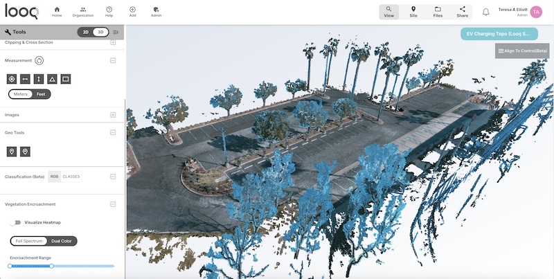
This detailed map, capturing topographical features and existing infrastructures, enable optimal positioning of charging stations, effective drainage designs, and integration of electrical systems while ensuring compliance with regulations. Image courtesy Looq AI.
The evolution of geospatial technology
The global geospatial analytics market is expected to grow significantly, from USD 78.5 billion in 2023 to USD 141.9 billion by 2028. This growth is driven by the increasing demand for location intelligence in sectors like energy, utilities, urban planning, and transportation. Technologies such as remote sensing, cloud-based processing, and AI are driving the industry forward, unlocking operational efficiencies of up to 30 percent.
We are in the midst of a geospatial revolution, often referred to as Geospatial 2.0. Technological advances like AI and new data collection methods have unlocked unprecedented insights and elevated decision-making capabilities. These breakthroughs are bridging the once-separate fields of geospatial and surveying. As we embrace the era of digital twins, surveyors play a critical role in delivering the precise base data needed to construct these 3D digital models, while geospatial professionals integrate and analyze this data to provide answers to questions that were once incredibly challenging.
Surveyors at the forefront of grid modernization
Surveyors are essential to the planning and maintenance of energy infrastructure, providing critical data to optimize the placement of power lines, substations, and renewable energy installations. They ensure regulatory compliance, enhancing operational efficiency, and reducing costs across energy projects. 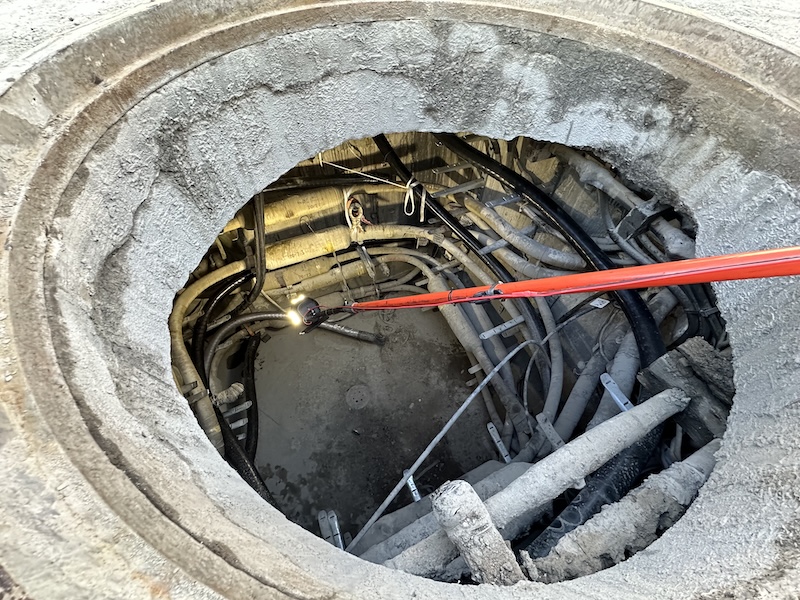
Advanced tools such as reality capture technology empower surveyors to create high-fidelity digital twins — virtual models that are crucial for infrastructure planning and grid modernization. These digital twins allow utilities to simulate and optimize energy distribution. For instance, LiDAR systems, machine learning (ML), and artificial intelligence (AI) techniques streamline vegetation management around power lines, reducing the risk of outages caused by encroaching vegetation. This efficiency is driving significant improvements in grid resilience. (Right: Looq AI's qCam captures detailed 3D data from manholes, keeping surveyors safe and efficient. Image courtesy of Looq AI.)
Revolutionizing grid infrastructure with AI and digital twins
Digital twins offer transformative capabilities for grid systems. By integrating real-time data and predictive modeling, these virtual models enable utilities for:
- Optimizing energy distribution: AI algorithms analyze data patterns to maximize energy efficiency and anticipate grid stress points.
- Predictive maintenance: Digital twins help utilities identify potential failures before they occur, reducing downtime and ensuring consistent energy flow.
- Enhancing Resilience: In the face of extreme weather, digital twins provide valuable insights that improve recovery times and overall grid reliability.
For utilities managing aging infrastructure, digital twins are invaluable for monitoring the condition of assets and prioritizing maintenance. These advancements contribute to greater reliability and long-term sustainability.
Breaking down technological barriers
Earlier reality capture techniques, like on-the-pole photogrammetry, were limited by high costs and complexity. Today, handheld photogrammetry systems integrated with GNSS/IMU positioning are revolutionizing the field. These tools automate data processing and deliver survey-grade results, making high-precision geospatial data more accessible to a broader range of professionals.
These innovations also support grid modernization efforts by helping utilities extend the life of aging infrastructure. For example, utilities are using reality capture technology to assess transmission poles, many of which are over 50 years old. This proactive approach enables upgrades before vulnerabilities become critical.
The workforce challenge and opportunity
As geospatial technologies continue to evolve, the demand for skilled professionals rises. Nearly 50 percent of the current workforce is set to retire in the next 15 years, creating a talent gap. Educational institutions are responding by offering specialized programs to train the next generation of surveyors and geospatial professionals for complex infrastructure challenges.
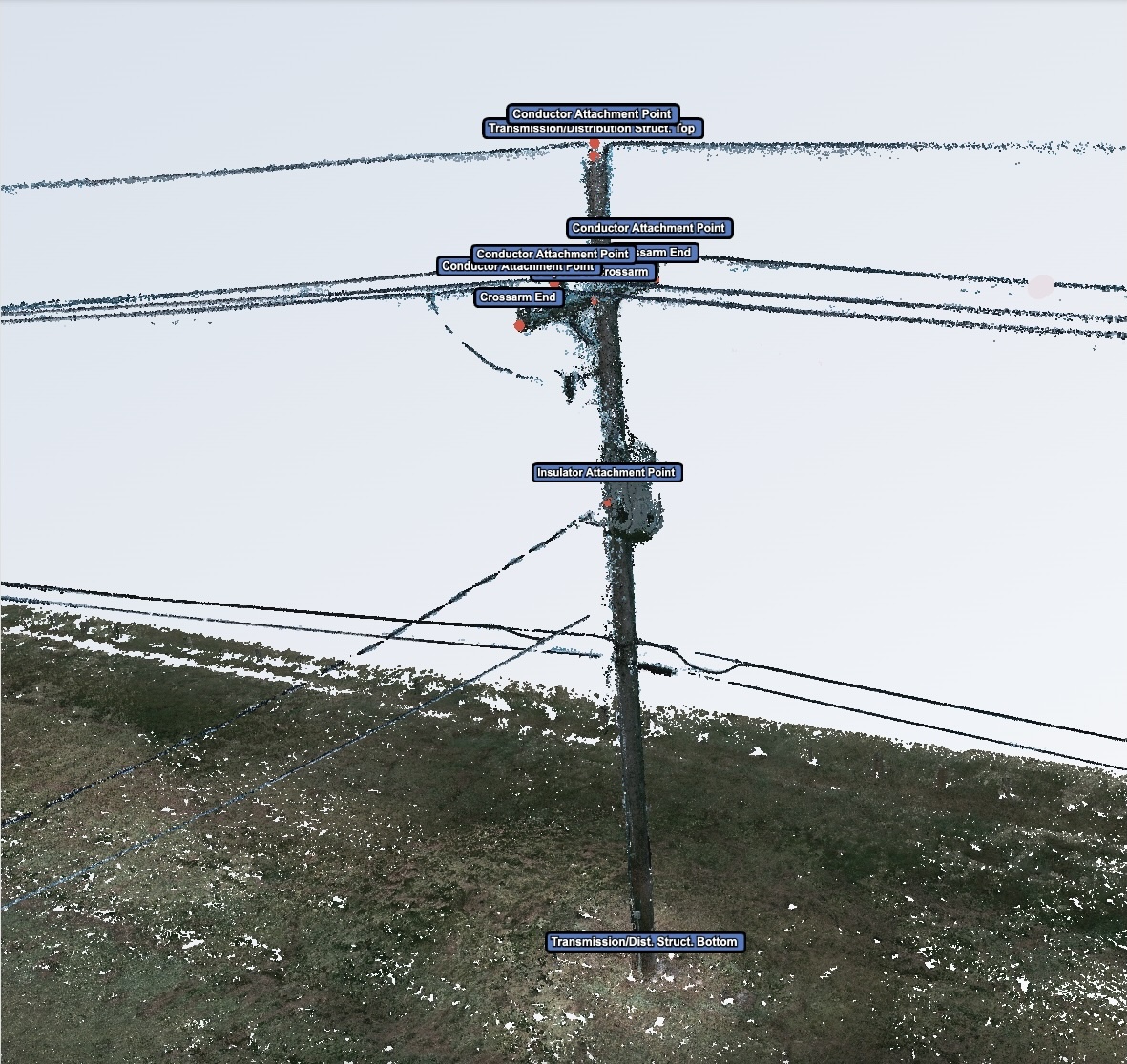
Close-range photogrammetry (CRP), with a terrestrial hand-held unit, supported by sophisticated AI algorithms, providing superior spatial resolution and rapid data processing, and visualization and analysis via a web app environment.Image courtesy of Looq AI.
A unified approach to grid resilience
A sustainable and resilient energy future requires collaboration between surveying, GIS, and engineering fields. By combining AI, reality capture, and digital twins, these disciplines foster smarter decision-making and enhance grid resilience. Surveyors are central to this ecosystem, converting geospatial data into actionable insights that contribute to grid modernization.
In a world facing aging infrastructure and climate change, the geospatial sector is helping lay the foundation for a smarter, more connected energy grid. The work of innovative companies in the geospatial space is crucial to this effort, ensuring that grid infrastructure is resilient, sustainable, and ready for future challenges.
Powering a resilient energy future
Surveyors and geospatial professionals are more than participants in grid modernization — they are its architects. By leveraging AI and digital twin technology, they bridge the physical and digital worlds to build adaptable, reliable energy systems. Emerging innovations, such as quantum-enhanced geomatics sensors, promise even greater breakthroughs.
As the energy sector evolves, surveyors will play a pivotal role in delivering the precision and foresight needed to ensure modern, reliable energy systems are accessible to all. Through their expertise, we can create a future that is not only sustainable but also resilient.
Practical applications for grid modernization
The integration of geospatial tools is transforming how utilities approach grid modernization, resilience, and the growing energy demands of the future. Some key use cases include:
Grid assessment and modernization
- Challenge: The U.S. grid has over 200 million distribution poles, many of which require upgrades or fire safety assessments.
- Solution: Geospatial technology drastically reduces fielding time, enabling tasks that once took hours to be completed in seconds. This accelerates planning and engineering, helping prioritize necessary upgrades and increasing operational efficiency.

Advanced tools such as reality capture technology empower surveyors to create high-fidelity digital twins—virtual models that are crucial for infrastructure planning and grid modernization. Image Looq AI qCam | Courtesy Looq AI
EV charging infrastructure
- Challenge: The rapid adoption of electric vehicles (EVs) demands widespread and reliable charging infrastructure.
- Solution: Geospatial tools enable field technicians to create detailed digital twins of potential EV charging sites in under 10 minutes. This speeds up coordination between agencies, ensuring projects remain on schedule and within budget.
Utility undergrounding
- Challenge: Coordinating utility undergrounding projects is costly and prone to errors due to inaccurate records.
- Solution: Geospatial tools provide precise topographic surveys and accurate data capture, improving safety, reducing errors, and streamlining coordination across agencies.
By embracing these technologies, utilities are modernizing their grids to be more resilient, efficient, and prepared for future challenges, ensuring reliable energy for generations to come.
Christine Byrne is the PR and Communications Director for Looq AI, which uses camera and software design to overcome global-scale infrastructure challenges. Looq AI makes asset data accessible to people to bring transparency to projects, efficiency across organizations, and safety to our society. Christine can be reached at: [email protected]
Looq AI | www.looq.ai
Author: Christine Byrne
Volume: 2025 July/August