

Ready for Winter Ice?


After last winter, bringing up a topic such as ice accumulation to turbines may draw a few groans. If anything, it confirms just how significant the impact of extreme cold and icing can be on wind turbine performance and production. Of course, there is nothing you can do to actually stop the meteorological icing event from happening, but there are steps you can take to recognize - and prepare for - icing. There are additional steps you can take to mitigate the total impact of an icing event, and even position your site for a faster return to full production.
Understanding the Impacts
The impacts of icing to wind turbines are both safety- and production- based. Ice accumulation on blades can lead to ice throw, which can be dangerous to onsite employees and, potentially, the general public. Even stationary wind turbines can shed large chucks of ice. This not only creates a further safety hazard, but the accumulation of ice on blades increases component fatigue from load, and can increase noise levels. Perhaps most importantly, the production of the turbine will be reduced due to loss of aerodynamic properties, resulting in less power output. Continued ice accumulation and rising safety concerns may lead to total shutdown of the turbines, perhaps for days at a time. When that happens, the financial losses can be huge.
Recognizing the Threat
The threat of ice accumulation is not always obvious. The most well understood icing event is freezing rain. That may be because it is widely advertised by local weather sources, and rarely sneaks up on anyone. However, it's often the less recognized events of freezing fog and heavy wet snow that cause bigger headaches. A wind driven, heavy, wet snow can stick to almost anything; due to high moisture content, the weight of accumulating snow piles up fast. A worst-case scenario is a heavy, wet snowfall lasting 3-6 hours, followed by a sharp drop in temperature in a short period of time. This can create a "flash freeze" that essentially bonds the accumulation to whatever it has fallen on - even a turbine blade. That ice will stay on the blades until the sun returns and temperatures warm.
Freezing fog, on the other hand, can form in several ways. One method that often sneaks up on renewable energy professionals is when a cold, shallow arctic airmass undercuts an existing moist airmass in place. Temperatures at the wind site might be in the upper 30s to near 40, and a couple of hours later it can be 25 and windy, with freezing mist and fog coating your blades, and you're suddenly blindsided by a major drop in production.
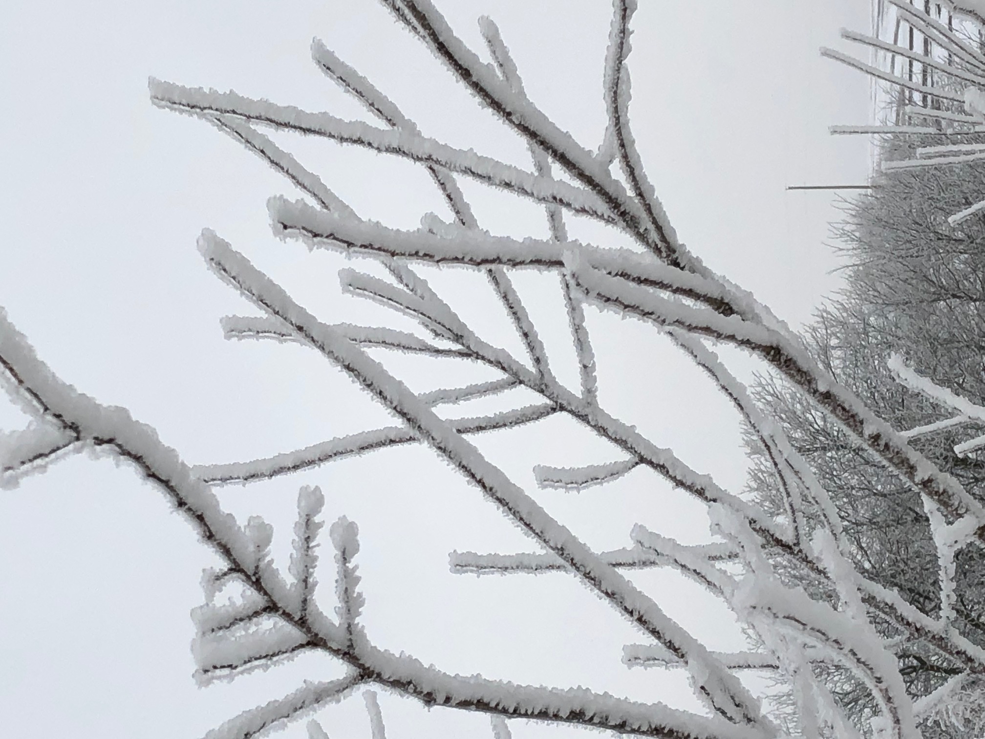 (Left: ice accumulation from freezing fog event in Kansas)
A final icing event happens in locations near water (such as an ocean) and locations that are elevated. This event is called in-cloud icing. It's the king of icing because you can literally experience the characteristics of precipitation based icing and freezing fog at the same time. Because of that, in-cloud icing events can be extreme, and result in the most significant production losses. Locations such as New Brunswick, Nova Scotia, and the northwest United States, are more prone to this type of icing event. Even more challenging is that some of your turbines at lower elevation may not see any icing, while turbines at high elevations could be shut down.
Mitigating the Event
There are plenty of public and private commercial weather sources that predict icing. For the unique needs of a renewable energy professional, commercial sources may be the best option. One reason is that they can spend more time focusing on forecasting the freezing fog and heavy wet snow events that can exceed the impact of freezing rain events. They can also supply raw forecast data feeds, which allows the client to ingest the data in house for creating internal portal sites and dashboards that monitor production. Many commercial providers also have Meteorologists on staff that can support the client in collecting information and data that summarizes the severity of the event.
For these reasons, renewable energy professionals should rely on high resolution weather forecasts from commercial providers that focus on addressing the impact to your wind farm. By alerting you to ice accumulation days in advance, commercial providers enable you to adjust production forecasts, rearrange maintenance plans, and review safety protocols.
Don't forget about the post icing event weather! Once the icing is over, when does everything return to normal? Temperatures below 32 with cloudy conditions will do little to remove ice from the blades. If the accumulation is substantial, you may not be able to run the turbine at all. Rising temperatures and sunshine are a good sign, but also precede melting ice - that means crews returning to work too soon could face danger from ice falling off the wind turbine. Likewise, starting the turbines too soon could send ice missiles flying hundreds of yards, presenting another serious safety hazard. Paying close attention to post icing event weather is equally important as preparing in advance of the icing event.
 (Right: missing piece of ice from turbine blade)
Preparing, Planning, Execution, and Recovery
You can't stop the weather from happening, but you can prepare for it. Watch forecasts closely for all types of icing - not just the obvious events. Once you know an event is on the way, make sure you have a plan. Off-takers and power marketing teams should know how production could be impacted, and when. Look at the maintenance schedule for that day - does it need adjusted? Once your plan is formulated, make sure to execute it. Continue to check forecasts regularly to see if the event is getting worse or the threat is passing. As ice accumulates, monitor production closely, and stop turbines as needed. Once the icing event is over your work still isn't done. You still need to execute your plan as you head into the recovery stage. Knowing when the ice will begin to melt is important. When is it safe to return to outdoor work? When will production recover to normal levels?
Ice events may be one of the most challenging natural hazards you will face. Unlike lightning stand downs, which usually last hours, or high winds, which rarely exceed a day, an icing event can last days, a week, or more. Impact to production, maintenance, and safety can be unmatched by any other hazard. Learning to recognize these events in advance by using all sources available can lead to better preparation and mitigation. Ultimately, you will lessen the financial impact while maintaining a high level of safety.
Marty McKewon is Chief Meteorologist at Indji Systems, a provider of weather monitoring and alerting solutions to the Renewable Energy Industry. Marty has 30 years of weather industry experience, including roles as a Meteorologist, Product Manager, and Sales Professional.
Indji Systems | www.indji.com
Author: Marty McKewon
Volume: 2019 September/October