


Wind Farm Siting Software Solutions


 It cannot be overemphasized: deciding on a suitable location for a wind farm and each one of its turbines is critical to a project’s success. There are, however, many complex issues associated with wind project siting, beyond determining the availability of a strong and consistent wind current.
Although the possibilities are seemingly endless when it comes to finding land to develop wind energy, certain sites can be removed from consideration quickly based on federal, state, and local government regulations and restrictions; land use and geological constraints; and adverse impacts to the environment and wildlife.
Turbines work best on high, exposed sites. Hilltops are ideal, providing there is a flat enough area, suitable for tower construction. The vicinity should be clear of obstacles, which could interfere with the wind current or operation of the turbines—and clear enough to transport the construction and maintenance crew, not to mention, the turbines themselves.
For those locations that pass these tests, and are regarded as feasible sites, still more data is needed, including: the availability of wind; topography; proximity to power lines; existing infrastructure; land ownership; population density; plus, the costs of clearing and developing the land and required access roads.
As one tool in the process, wind farm planners are finding Web-based software to be an efficient and useful application to help with all the possible data to consider when it comes to wind energy siting. The software automates much of the information essential to making important project siting decisions.
Data collection challenges
 Before deciding on location—and not just for a wind farm itself, but individual tower placement must also be considered—siting of one or more meteorological (met) towers is necessary. The met tower’s attached anemometers and wind vanes measure wind speed and direction. Credible wind data is paramount for successful siting, but long-term measurements are expensive.
One met system alone can cost tens of thousands of dollars, and that doesn’t cover the staffing necessary to collect the data. Moreover, most wind farm projects don’t allow for a long timetable for development, but at least one year of met data is recommended. These collective factors require optimal met tower siting.
Wind power project siting is a complex project in and of itself. With a substantial investment on the line, developers resort to various means to arrive at what they hope will be an optimal decision. Some companies still work traditionally, from pen and paper, as the initial investment is low when doing calculations by hand. However, the margin for error is higher—particularly, as more variables are added into the mix.
As more factors—such as wind speed, regulations, and costs—are considered, the metrics and rules grow exponentially. This traditional approach quickly becomes unsustainable.
Web-based solutions
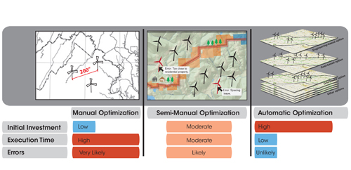 To mitigate these risks, other companies take the semi-manual approach. Through computer-assisted design, planners simulate possible locations through a geographical information system (GIS) interface, gaining instant feedback with each change of spatial orientation of the turbines. This feedback includes values of desired calculated metrics. It also “red flags” certain locations when any siting rules defined at the outset are violated.
GIS mapping is invaluable, and offers results in seconds rather than days. It also provides data on weather patterns, including the wind, as well as information on topographical and environmental consideration. Yet another overlay can illustrate surface and sub-surface infrastructure, which provides important measurements of the proximity to power lines and utility lines.
This approach, however, is time-consuming. There are innumerable turbine placements a developer could test within a proposed wind farm space. This long, arduous process could end with what is considered only the best of countless possibilities, but not necessarily the best siting choice.
Another option to consider is an automated approach, which takes the guesswork out of siting. A multi-objective adaptive heuristic algorithm can automatically search and provide planners a set of near optimal solutions that meet a project’s criteria. Also known as genetic algorithms, these computer instructions adapt Charles Darwin’s evolutionary model. The process interchanges design elements in hundreds of thousands of different combinations. Only the best-performing combinations are permitted to survive.
A wind farm planner defines areas of interest and project objectives, ranking factors on a weighted scale for order of importance. The software performs a directed search within that space, and determines several siting solutions, numbering them in order of best fit. The process works especially well in a large area, like a wind farm. In this case, arriving at a near optimal solution can statistically be guaranteed.
Of course, the software will still need to be fed the siting information and variables. For example, data from the met tower, along with any online information, and any information the wind farm planners deem as essential. But using an automated approach eliminates much of the time spent developing wind farm layouts, selecting the one that best suits a project’s needs. If any underlying factors change, re-evaluating and changing the options is simple, and requires minimal re-work.
When GIS data is integrated into this software, mapping data can be applied to information from local agencies and third-party providers. Planners learn quickly about zoning or government restrictions. They obtain information about environmental or wildlife impacts. Title information on individual parcels, which previously took days to research at the county courthouse, is available instantaneously and can greatly speed the right-of-way negotiation process. Multiple possible wind farm locations and placements of the turbines can be studied, and the best sites quickly determined.
Multi-objective adaptive heuristic algorithms have been used across other industries to solve the same type of complex problems wind farm planners face in siting decisions. Financial organizations have used them to formulate trading strategies. The method even has been used to arrange a constellation of satellites in space, and to engineer the design of a satellite antenna.
A wind farm is a significant investment in time, money, and resources. Maximizing the return on that investment, however, doesn’t necessarily start with siting. With the capabilities of automatic optimization, securing the right software technology could be the best first step to a successful wind energy project.
Dan Liggett is the Communications and Public Relations manager for geoAMPS, a technology company that specializes in software solutions to manage land rights and infrastructure assets.
geoAMPS
www.geoamps.com
Author: Dan Liggett
Volume: January/February 2013