


Solar Resource Assessment: Improving Accuracy and Enhancing Project Performance


 Accurately assessing how much power a solar project will produce is a crucial factor in securing financing and seeing a project from development to operations. As solar capacity grows worldwide, an increasing number of operational projects are performing outside the range of initial expectations. As a result, the industry is beginning to take greater interest in resource assessment, how solar energy estimates are calculated, and how the process can be refined.
The financial consequences of errors in solar resource estimates are considerable, equating to reductions of up to 5% in energy produced, and millions of dollars in lost revenue over an asset's lifetime.
In terms of performance variability, the single greatest influence is weather. It is, of course, impossible to predict weather conditions onsite throughout a project's lifecycle with 100% accuracy. However, developers have many options throughout the pre-construction phase to improve resource assessment accuracy and overall solar plant performance.
Combining site-specific analysis with longer-term performance data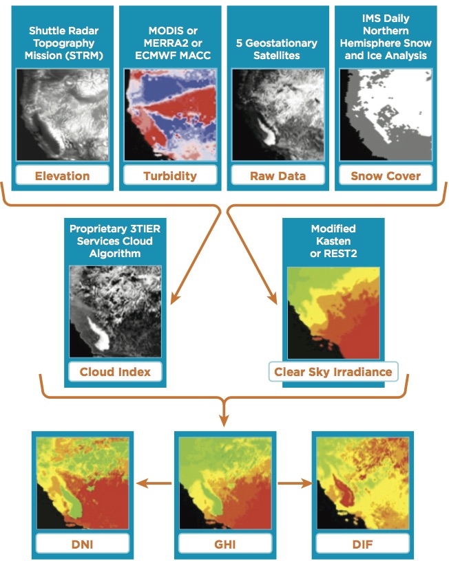
When prospecting for sites, developers typically carry out GIS analysis by overlaying transmission and energy pricing data with solar irradiance, temperature, and wind speed information, which is often publicly available.
While this method enables the selection of a site, it is important to combine it with more accurate, long-term data that accounts for solar performance at hourly intervals. Data of this kind provides the best indication of how a project will perform over its lifetime, and allows for the 1-year P90 calculations required for financing. This value indicates the production value the annual energy output is expected to exceed 90% of the time.
Assessing satellite data sources
Due to the scarcity of long-term direct observation networks, a number of companies provide satellite-derived solar resource datasets, each of which offers essentially the same information. However, these datasets vary in their inputs and how they calculate surface irradiance. As a result of different methods, the scope for error and uncertainty can vary significantly between sources.
For instance, information gleaned from public sources typically has a high degree of uncertainty. NASA's global dataset has a 20% uncertainty, while, depending on the version, the uncertainty for NREL's datasets for North America can range from 5-12%. By contrast, high-quality data from a paid provider will reduce the degree of uncertainty by half.
How well data has been kept up-to-date is another critical factor in selecting a weather data source. This is important because aerosols, such as air pollution, substantially influence solar power performance and have grown dramatically over the past ten years in parts of the world, particularly China and India.
Evaluating dataset validation and site-specific accuracy
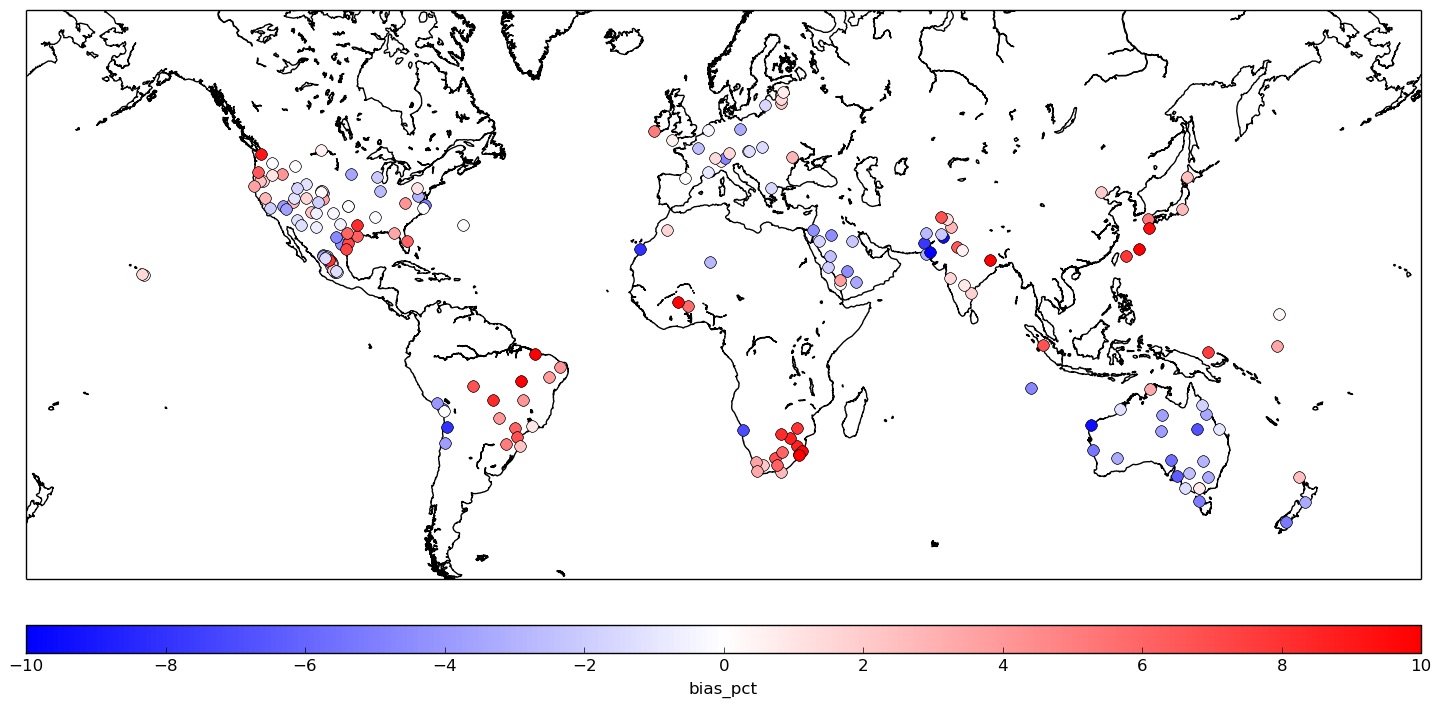 Developers must evaluate how the dataset they employ was validated, and its accuracy in the region where a project is located. Data providers demonstrate accuracy by comparing datasets with direct observations from publicly available ground stations.
In some cases, data providers have also used these ground stations to calibrate or enhance the accuracy of solar resource information. A fair and unbiased verification study reserves at least a subset of ground station data exclusively for validation purposes to provide users with an accurate estimate of how the data will perform at their project locations. As a user, it should be clear to you which validation points are independent and which are not.
As solar spreads around the world, ensuring the availability of accurate, consistent data is increasingly importance in driving development. When selecting a data source, it is vital to ensure it has been validated against ground stations in the site's vicinity, since regional factors - such as pollution, dust or seasonal variation - have considerable influence on solar resources and power generation.
Ideally, developers collect long-term weather data from the same provider during the initial evaluation phase as will be used during financing. In doing so they avoid any difficulties caused by sudden and dramatic shifts in energy yield estimates related to a change in the resource data source.
Driving down resource uncertainty
In addition to sourcing high-quality data, further measures to reduce uncertainty can and should be undertaken. This is particularly useful in situations where a comparison of multiple solar data sources indicates a wide spread in the numbers obtained.
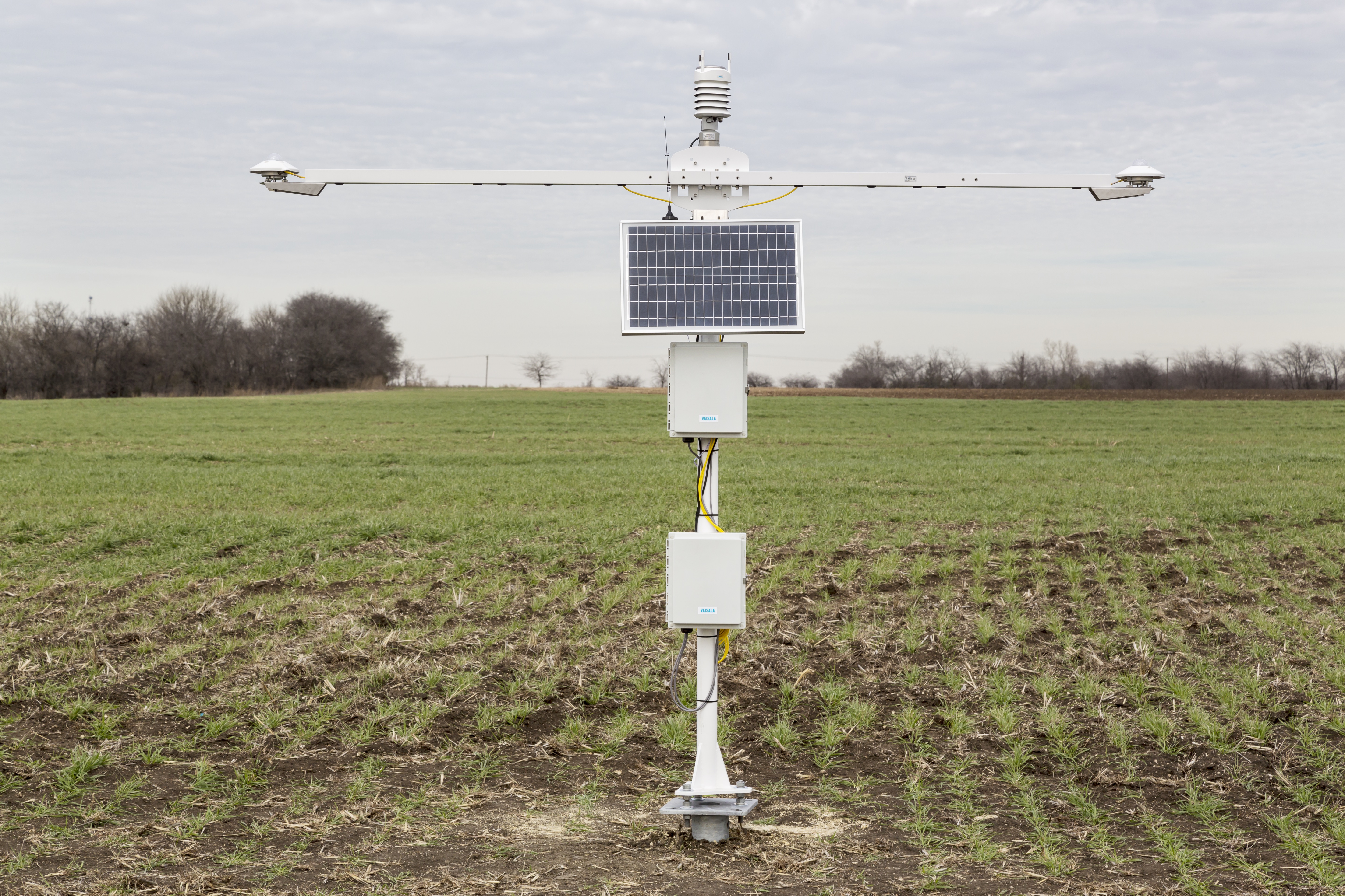
Debt-financed projects, where a direct improvement in uncertainty is tied to better finance terms, can benefit from installing a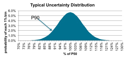 privately-owned ground station at the site. The observations collected capture micro-scale features that may be overlooked by satellite-derived datasets, but significantly affect power performance. Stations provide real-time condition monitoring of irradiance, but also typically measure wind, precipitation, and temperature and sometimes soiling rates. In addition, developers can use historical information from ground stations to make engineering decisions and budget maintenance costs.
Site-adapted estimates by investing in high-quality equipment
To produce a "site-adapted," or corrected, record of solar resources, a technique known as model output statistics (MOS) is used to combine long-term satellite data with direct measurements. This is the gold standard in solar resource assessment and has proven to reduce resource uncertainty by up to 50%.
However, measurement equipment reliability and maintenance practices are imperative to the success of the approach. Investing in a low-quality system, or failing to maintain one of higher quality, can be counter-productive, since it adds time and drives up costs associated with quality controlling the data and screening out erroneous readings.
Anticipating extreme weather
Finally, as solar development enters into regions prone to extreme weather, it is increasingly worthwhile for developers to factor in the susceptibility of their projects to severe conditions. Analyzing the possibility of equipment or site damage in areas where lightning, hailstorms, or high winds are common is essential when evaluating insurance options. Snowfall and smog from volcanic eruptions or wildfires also hinder solar energy production. Instances of extreme weather, while hopefully rare, should be accounted for when making energy projections.
As discussed here, there are a number of factors underpinning the accuracy of solar assessments that developers need to consider. In order to maintain the growth of solar, the industry must ensure resource assessments are carried out in line with best practice, or risk paying higher financial and reputation costs down the line.
 Gwendalyn Bender, Head of Solar Services, has been supporting solar developers and operators since 2009 and played a critical role in the development of Vaisala's 3TIER global solar dataset. Ms. Bender is active on a number of educational solar committees and has given numerous technical solar presentations at industry events around the world.
Vaisala | www.vaisala.com
 Francesca Davidson, Energy Communications Expert, has nearly nine years of professional experience within the renewable energy sector and a deep knowledge of the solar and wind project lifecycle. Ms. Davidson's primary areas of expertise include, strategic planning, technical writing, project management, and media relations.
Vaisala | www.vaisala.com
Volume: 2017 September/October