Page 14 - North American Clean Energy March April 2015
P. 14
wind power
Increasing the
Eficiency of Aerial
Surveys
By using tablets for
project siting
By Matt Alexander
AERIAL SURVEYS ARE A METHOD of collecting valuable geomatics or site data for a project,
which can be efective, but also expensive and time-consuming. hese surveys can also,
potentially, impact the wildlife on location and can be technologically diicult to navigate
and document the data with ease.
Nonetheless, aerial surveys are often conducted prior to and post-construction,
particularly for renewable energy projects—either to comply with regulations or to
minimize asset loss. Fortunately, evolving technology is creating new opportunities to
address these needs that increase aerial survey eiciency, thereby, saving developers,
investors, and agencies time and money.
Traditional methodology
To successfully complete an aerial survey, biologists have three general requirements,
including the ability to:
1. View the location of interest inside the survey boundaries;
2. Record the global positioning system (GPS) points; and
3. Record the light path to track progress and achieve agency reporting requirements.
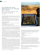
To meet these requirements, biologists often utilize traditional methodology, which tend Conducting an aerial site survey at a potential wind farm with the help of a tablet, paired
to include the use of a handheld GPS unit with a pre-loaded map. his demonstrates the with external GPS receivers
survey boundaries, and includes an electronic data form, which documents the location
and information on nearby nests, vegetation, etc., in the GPS. Additionally, biologists use
paper datasheets and even printed maps (aerials or quads) as a backup for navigation and
documentation.
locations with a touchscreen); and to upload all of the data quickly at the end of the day,
Use of a handheld GPS unit provides some beneits, including the ability to record data without transcribing additional data from paper maps. Some GPS receivers will also allow
points within a three-meter accuracy, along with the ability to electronically capture GPS users to automatically export a KMZ ile that shows the light path in Google Earth.
coordinates and transition these points to a GIS database without manually transcribing Although many tablets have the capability of performing these functions, compare
them. However, there are also several pitfalls associated with this technology.
speciications, such as:
For one, these handheld devices are not speciically designed to track the user or record • Design durability (and availability of a waterproof case);
GPS data while lying and, therefore, they rarely communicate with satellites fast enough • Battery life;
to adequately track the helicopters location. his commonly results in technical glitches • Mobile GIS apps;
with the device during the survey, which can often lead to the need for additional light • Compatibility with external GPS receivers; and
hours. Secondly, it’s diicult for biologists to track their location on the small screen of the • Longevity in the market.
GPS device, particularly when the survey area is extensive. Lastly, utilizing a satellite image
of a large project area can bog down the memory of the GPS unit, causing the unit to crash.
Conclusion
To date, in a number of case studies and projects where the tablet solution has been
New technology
employed, aerial survey hours have been cut by 20% to 30%, based on a comparison of
Recent technological advancements in the form of tablets with mobile GIS software, paired light hours using traditional technology. hese cost savings were a direct result of easier
with external GPS receivers that are designed for light applications, are providing new navigation, quick GPS coordinate recording, better mapping of the light path, and the
opportunities for aerial surveyors. hese tablets can substantially increase eiciency and external GPS receiver’s ability to maintain position information without glitches.
accuracy of site surveys, while simultaneously reducing the potential impacts to wildlife.
In these projects, the tablet solution has been extensively used for ield and aerial
When paired with a GPS receiver, a tablet increases survey eiciency, thereby reducing surveys, including: routing surveys; threatened and endangered species surveys; aerial
the total light hours. As renting a helicopter and a pilot can cost upwards of $1,600 per raptor nest surveys; eagle point count surveys; noxious weed monitoring; habitat mapping;
hour, the cost of a tablet device and software is easily outweighed in this case by the cost in and wetland delineations. he potential for this technology will only continue to expand,
time saved during a survey. hese eiciencies are achieved through several beneits during providing additional opportunities for developers and agencies to save time and money in
the survey, including: the use of an afordable external GPS receiver that communicates
the future.
up to ten times faster with satellites; a reduction in glitches during the survey; elimination
of the need for cellular service to ind one’s current location; and more accurate tracking
Matt Alexander is a senior biologist and mobile technology specialist with Ecology &
of the light path. Moreover, a table with software has been shown to provide greater Environment, Inc., an environmental consulting irm. He has 18 years of experience designing,
accuracy, saving on post-survey data documentation.
leading, and conducting ield surveys across North America—working on wind, solar,
his increase in eiciency and ease of use are made possible by a number of reasons, transmission, and other energy projects.
including: an ability for a surveyor to more easily record data points electronically; to
view the entire survey area over satellite imagery (and quickly zoom in and out to speciic
Ecology and Environment, Inc. | http://www.ene.com
14 nacleanenergy.com
MARCH/APRIL 2015