Page 23 - North American Clean Energy January February 2015
P. 23
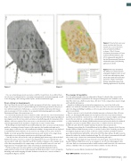
Figure 2. Visual of side-scan sonar
mosaic used near the Neart na
Gaoithe site, so as to determine

areas of seabed resemblance
to Annex 1 “Reef ” Criteria
(Preliminary Assessment of Coarse
Sediment Benthic Habitats, July

2011; subsequently appended to
the inal Environmental Statement
submitted as part of the planning
application in 2013)


Figure 3. Biotopes identiied by
the ofshore site characterization

using grab, dropdown video, as well
as side-scan and bathymetry data
(Neart Na Gaoithe Environmental
Statement, Chapter 14: Benthic

Ecology; submitted as part of the
Planning Application in July 2012)

Figure 2.
Figure 3.


Once an exclusivity agreement was in place with he Crown Estate, focus shifted from The design & feasibility
site selection, to information for consenting (environmental constraints mapping), as well Once the planning application was submitted to Marine Scotland (a Directorate of the
as site designing (cable routing, turbine layout, and the foundation design).
Scottish Government, responsible for the integrated management of Scotland’s seas) in

July 2012, there was a shift in marine data collection—from ecological data to pure design
From siting to development
and feasibility information.
Like Cape Wind, the site for Neart na Gaoithe was approved, but before construction can A number of additional geotechnical investigations were carried out, both at the
begin, several more steps are required. Although an exclusivity agreement for the project ofshore site and in the intertidal and coastal cable route. hese were done to look at the

lease with the landowner is fully in place, consent to build the wind farm still remains cable trenching and drilling feasibility, as well as to gain information about possible cable
some years away yet. It’s been subject to an unpredictable planning application and the protection methods.
Environmental Impact Assessment process.
Prior to consent, it can be beneicial to identify innovative solutions to data collection.
It seemed only prudent, therefore, to irst focus data collection on critical environmental In this case, loating LiDAR deployment was deployed, wherein a buoy-mounted wind

data, such as bird and marine mammal surveys. Steps toward the irst stages of geophysical speed measurement device was used. As a result, it wasn’t necessary to employ a metrology
investigation over the site have also been taken, as has bufering and determination of the mast at the site, which is a costly and time-consuming undertaking. However, to meet
ofshore cable route options. hese surveys were carried out back in the summer of 2009, accredited standards, the loating LiDAR wind measurement buoy irst had to be validated

and took approximately two months to complete due to some weather delays.
alongside a met mast at another UK location, before it could be moved to the Neart na
Methodologies included multi-beam swath bathymetry, side-scan sonar, and sub-bottom Gaoithe site and collect the valuable wind speed and direction measurements.
proilers, consisting of seismic boomer (at the main site for foundation design) and a Planning consent from the Scottish Ministers for the ofshore elements of the Neart na
seismic pinger (cable route for cable installation feasibility). A magnetometer was deployed Gaoithe Ofshore Wind Farm was, at last, received in October 2014. Detailed geotechnical

to identify major items of debris, wreck, and even any changes in near surface bedrock. investigation began just prior to that, in the late summer of 2014, and further detailed
Finally, an acoustic ground discrimination system was used, interfaced to a single-beam geotechnical information will still be collected in 2015. his data will speciically be used to
echosounder, so as to determine variations in seabed types and habitats.
inform the turbine-by-turbine foundation design. he collection of environmental data will
Critically, for data collected in the early, pre-planning application stages (when the inal also resume as pre-construction environmental monitoring takes place.

build-out decisions weren’t yet certain), it was important to focus on relatively low-cost hroughout the development stage, from site selection to post consent, the Neart na
surveys, which could collect data that was it for a number of purposes. For example, much Gaoithe Ofshore Wind Farm serves as an example of cost-efective and pragmatic data
of the data was primarily for the engineering—such as the multi-beam, side scan, and collection. And, in an environment where (unlike onshore wind farm sites), the remoteness
magnetometer—forming the basis of the archaeological environmental baseline.
and inaccessibility of the area requires the utmost conidence in data collected.

Further to this, side-scan sonar and the acoustic ground discrimination system
augmented the benthic survey (sediment grabs and drop down video), so as to extrapolate Tom Morris is a senior Marine Consultant with Fugro EMU Limited.
knowledge and enable mapping of benthic habitats across the site (cross use of data is
exempliied in Figures 2 and 3).
Fugro EMU Limited | www.fugroemu.com


North American Clean Energy 23