
Page 8 - North American Clean Energy January/February 2019 Issue
P. 8
top story
Using Infrared Drone Technology to Test
Wind Turbines
by Tim Leggett “The Drone Guy”
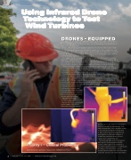
DRONES - EQUIPPED
with high-resolution digital and infrared cameras, and connected to GPS satellites by real-time kinometric (RTK) positioning - are revolutionizing how wind farms are inspected and maintained.
Today, a drone can inspect multiple turbines in the time it used to take to climb one. ermographic inspections that used to require two to three technicians and several days, can now be completed with one drone and one technician in just a few hours. No longer is it necessary to subject inspectors to safety risks as they climb to extreme heights, using only harnesses and ropes.
According to the U.S. Department of Energy, 6.3 percent of the nation’s electricity supply was contributed by wind energy generated by more than 80,000 turbines. All of these turbines require regular inspections, so that structural problems can be discovered before they become more extensive, and signi cantly impact energy performance.
Infrared/thermal testing refers to a non-destructive inspection process that uses thermography or infrared cameras. e testing can be performed in a variety of situations to detect problems before they become larger issues. As a testing technique, it is accurate, repeatable, and economical.
To perform a thermographic inspection of a wind turbine, the technician connects the drone to the RTK, a satellite navigation technology used to enhance the precision of position data, derived from satellite-based positioning systems such as GPS. RTK uses measurements of the phase of the signal’s carrier wave,
as well as the signal’s information content; it relies on a single reference station to provide real-time corrections, providing up to centimeter-level accuracy. e technique enables the drone
to y more accurately, and
stay stationary when hovering
and taking images, resulting in
more accurate data (and fewer
run-ins with the turbine).
Equipped with high- resolution digital and infrared cameras, the drone is rst own up the length of the shaft to detect any structural damage.
en it inspects the blades for anomalies. If the technician sees any damage from birds, ying debris, severe weather events, or any manufacturing defects that may
or may not have been anticipated from prolonged use of the wind turbines, a technician can y the drone closer to capture more detailed images.
ermal and high-resolution imagery/ data help the thermographer identify, classify, and localize each anomaly in a clear and consistent manner, to understand the impact of its performance on the system. Experts analyze the data, then share it with the end user, who walks away with a
8
JANUARY•FEBRUARY2019 /// www.nacleanenergy.com
